Emory Tract
Ross Gap to Rocky Fork
Overview
The Bird Mountain Segment marks the transition from the Cumberland Plateau to the Cumberland Mountains. From the small town of Wartburg, the trail will climb the spine of Bird Mountain, eventually reaching an elevation of over 3,000 feet before descending to Ross Gap. Currently, only 0.7 mile west of Ross Gap has been constructed.
However, acquisition of the Emory Tract as part of the “Connecting the Cumberlands” Initiative has provided public access for much of the future trail construction from Wartburg to the current piece at Ross Gap. Highlights of this Emory Tract Section will likely include vistas from the crest of Bird Mountain and the remains of historic coal mining near Ross Gap. This hike will access Ross Gap from the Rocky Fork Trailhead in Frozen Head State Park.
Trail Section Details
Features:
- Overlooks
- Wildflowers
- Fall color
Distance:
3.1 miles
Difficulty:
Moderate
Elevation Change:
4,400 feet gain and loss
Northern Terminus:
N/A Temp trail end
Southern Terminus:
(N36 07.507 W84 30.672)
Timezone:
EDT
Cautions:
No road access on the western end of this hike. Only a 0.7-mile section southeast of Ross Gap combined with a 2.4-mile spur trail down to the Rocky Fork Trailhead in Frozen Head State Park have been built.
Camping:
None available in this section. Big Cove Campground in Frozen Head State Park (FHSP) is 3.5 miles off the main CT from Ross Gap.
Topographic Maps:
Gobey and Camp Austin Quadrangles
Trailheads
There is no road access to the section of trail at Ross Gap. The closest parking is at the state park Rocky Fork Trailhead. To reach this trailhead from the east at the junction of TN 61 and 62 in Oliver Springs, drive 13.7 miles west on TN 62 to Flat Fork Road at a sign for FHSP. Or from the west, take TN 62 from Wartburg to Flat Fork Road in 1.9 miles. Turn north on Flat Fork Road and drive past the Morgan County Correctional Complex for 3.2 miles.
After a sharp curve right, turn left through an open gate and stay right on a small loop road across a grassy field to the signed trailhead at the edge of the woods. There are no facilities here except the parking area. Note that this trailhead is located before the gated entrance to the state park. The FHSP Visitor Center, 0.6 mile farther on Flat Fork Road, has restrooms, information, and map sales. To reach the CT from the Rocky Fork Trailhead, you’ll take the Ross Gap Connector Trail and then the Ross Gap Trail 2.4 miles to the ridge crest of Bird Mountain.
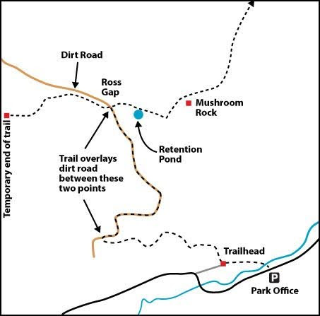
Map
Description
Mile 0.0 (3.1) From the Rocky Fork Trailhead (N36 07.507 W84 30.672), the short Ross Gap Connector Trail begins by following an old road across a shallow side creek.
Mile 0.05 (3.05) In 200 feet, reach a signed intersection with the Ross Gap Trail, which here is an old road. The trail to the right leads 0.3 mile to the FHSP Visitor Center but involves a potentially deep ford of Flat Fork Creek, depending on the season. A bridge is planned for this crossing. During high water, an alternative to reach the Visitor Center is to walk the shoulder of Flat Fork Road from the trailhead.
At the trail junction, turn left on Ross Gap Trail to head toward the CT.
Mile 0.1 (3.0) Reach the end of the old road and bear left on a foot trail at a sign acknowledging the efforts of a 2008 Americorps team that constructed this section of trail.
Mile 0.6 (2.5) Turn left off the end of the foot trail onto an old coal-mining bench. Because the coal seams in this part of the Cumberland Mountains lie flat, like the layers of a cake, the coal seams follow the contours of the mountains. Early miners extracted the easily available coal by following the seams along the contours, often leaving behind level benches.
Mile 1.0 (2.1) Turn right onto the old Ross Gap Road (N36 07.651 W84 31.349). This badly rutted dirt road connects Flat Fork Valley with the ridge crest of Bird Mountain at Ross Gap. Since the acquisition of this land by FHSP, the road has not been maintained and is closed to vehicle traffic, and so is suitable for foot travel only. (Do not walk the old road to the left down the mountain as it passes through private lands.)
Mile 2.4 (0.7) Reach the junction with the Cumberland Trail just below Ross Gap (N36 08.313 W84 31.314). On the east side of the gap, you’ll find a steel magazine once used for storing explosives and an angle iron frame; both remain from the last episode of coal mining in this area.
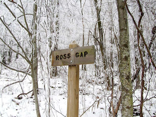
Ross Gap is the easiest and lowest access point along the crest of Bird Mountain and thus is crossed by several old roads and trails. Because these are unofficial trails, only experienced outdoors people should attempt to follow them.
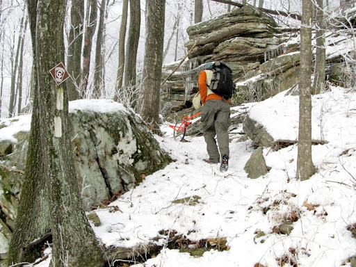
As of 2014, the trail west from Ross Gap has only 0.7 mile constructed by CTC volunteers. The route is complicated by numerous crossings of the old roads that radiate away from Ross Gap and, because the route is seldom traveled, can get quite overgrown. When this section is more heavily used, the CT route will be more obvious. For now you’ll need to keep an eye on the white blazes marking the trail.
At the junction of Ross Gap Trail with the Cumberland Trail, turn left on the CT’s Emory Tract Section. (If the trail left at the junction is overgrown, you can continue up the road to Ross Gap and take the road left up the mountain to pick up the trail at one of the crossings described below; look for white blazes.)
Mile 2.5 (0.6) The trail curves right and climbs above Ross Gap to cross the old road leading up from the gap.
Mile 2.7 (0.4) Recross this old road and then follow a coal bench off to the left before turning right onto foot trail.
Mile 2.8 (0.3) Join an old road on the south side of the crest of Bird Mountain, which merges left into another coal bench.
Mile 2.9 (0.2) Leave the coal bench for a foot trail on your right to climb above the coal bench and cross a steep slope within sight of the old coal bench below.
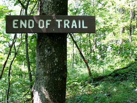
Mile 3.1 (0.0) The current end of this section is marked by a wooden sign (N36 08.275 W84 31.823).
The remainder of the Emory Tract Section has not yet been constructed. This section will likely follow the crest of Bird Mountain west to Low Gap and then Grapevine Gap. As it nears Wartburg, the route will turn onto the southeast slope of Bird Mountain and head almost due south toward Wartburg. From Ross Gap for about two and one half miles west to Low Gap, the long ridge of Bird Mountain was purchased as part of the Connecting the Cumberlands Initiative. The parcel between the ridge crest of Bird Mountain down to the Emory River on the north is known as the Emory Tract and was added to Frozen Head State Park and Natural Area in 2007 as part of the initiative.
— Hiram Rogers, FHSP Volunteer Trail Crew Member and CTC Board Member
More Information
One of the most important land parcels in the Connecting the Cumberlands Initiative was the addition of the Emory Tract to Frozen Head State Park.
The Emory Tract is an 8,000-acre property that extends north and west from the original park boundary at the crest of Bird Mountain northwest down to the Emory River. This critical swatch of mostly mature hardwood forest is now owned by the State of Tennessee.
The timely acquisition eliminated the threat of logging at the park border, similar to what occurred in 2002 along the park’s former northern border. Hardwoods were logged from tracts bounding the park on False Jury Ridge and Bald Knob while still privately owned. Where Frozen Head’s North Boundary Trail crisscrossed the park’s northern border, much of the trail was destroyed on the privately held northern side. But now that the State owns all this land, logging activities such as those on Bald Knob, England Mountain, Hall Branch, and that which was planned for the head of Phillips Creek will not happen.
While most of the original part of Frozen Head is managed as a natural area, the park will manage the Emory Tract differently, allowing hunting and ATVs for hunting-related activities.
— HR
Ross Gap Trails
With the multiple roads over the crest, the CT, and some old coalmine benches, Ross Gap is a fairly complicated spot. In addition to the CT, the old dirt road continues north from the gap, and two trails along old coal benches extend east and west from the gap along the north side of Bird Mtn. Though there are no official trails or named routes here, hikers exploring the area have attached names to many of the more prominent features. Because these are unofficial trails, only experienced outdoors people should attempt to follow them.
The old Ross Gap Road continues 4.3 miles north past Andrews Pond and down into Sang Branch to a ford of the Emory River to the paved Gobey Road at Gate 1 near the mouth of Sang Branch (six gated roads leading off Gobey Road are called Gate 0 through Gate 5 and were access roads for resource extraction that likely used existing older routes). On the right, the Frito Bench Trail (named for snack food found on an early Smoky Mountains Hiking Club trip) extends 2.0 miles east to Lake Williams on the crest of England Mountain and makes a fine, flat side hike. On the left, Marks Bench Trail (named for former CTC Board Member, Mark Shipley) follows the north slope of Bird Mountain to the west for 0.2 mile to a fork. The left fork will cross the Emory Tract section of the Cumberland Trail, while the right fork stays on the north slope of the mountain and leads to G-auger Pond (named for an old coal auger found nearby) and eventually to an old trail leading south along the crest of Bird Mountain.
— HR