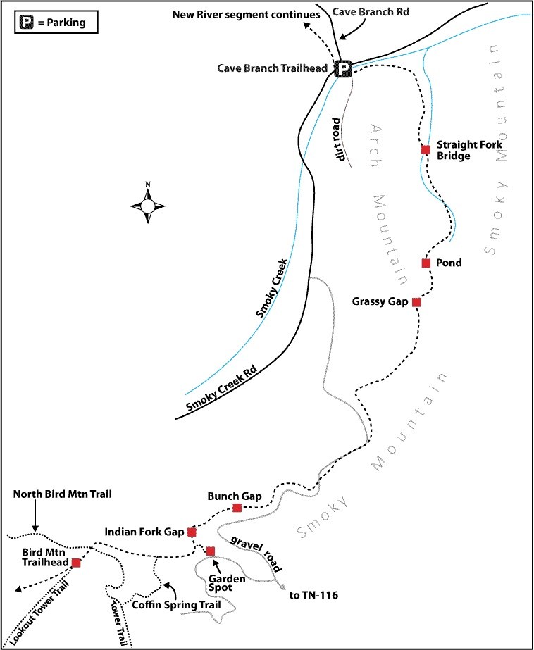
Arch Mountain
Smoky Creek Road to the Garden Spot
Overview
From the Bird Mountain Segment, the Cumberland Trail exits Frozen Head State Park, often-used by day-hikers, into the remote backcountry of North Cumberland Wildlife Management Area.
Although the Arch Mountain Section begins at The Garden Spot, this hike description starts at the intersection of the CT and FHSP Coffin Spring Trail. Just northeast of the Coffin Spring/CT junction are a few small creek crossings. Be sure to gather plenty of water here because the next seven miles of hiking will be in old coal mining areas and the creeks are likely polluted; no water should be taken from those sources.
From The Garden Spot for the next several miles, the Arch Mountain Section of the CT crosses ATV roads, which provides at times uneventful hiking but some challenges in picking up the blazes to re-enter the woods. However, many openings provide nice views of the surrounding mountains and valleys. Once on the ridgeline, the trail maintains an elevation at 2,900 – 3,100 feet, offering a comfortable pace reaching Grassy Gap before descending toward Arch Mountain.
The confluence of Straight Fork and Smoky Creek offer many water supply opportunities and peaceful hiking. There are no designated campsites in the North Cumberland WMA, but some good Leave-No-Trace (LNT) camping spots can be found at the base of Arch Mountain.
Before you reach the northern terminus at Smoky Creek Road, a ford of Smoky Creek will be necessary where you should search for shallow water for the safest crossing.
Trail Section Details
Features:
- Overlooks
- Wildflowers
- Fall color
Distance:
13.0 miles
Difficulty:
Strenuous
Elevation Change:
2,373 feet
Northern Terminus:
Smoky Creek Road (N 36 13.260 W084 23.142)
Southern Terminus:
The Garden Spot (N36 09.377 W84 26.510); currently no trailhead access; Coffin Spring/CT junction (N 36 09.313 W084 26.992)
Timezone:
EDT
Cautions:
Hunting in season; check with TWRA on dates and wear blaze orange
Camping:
No designated backcountry campsites
Topographic Maps:
Petros, Fork Mountain, and Norma Quadrangles
Trailheads
There is no road access to the southern terminus of this section; so the Cumberland Trail at this location must be accessed from trails within Frozen Head State Park.
To reach FHSP from Harriman, take US 27 north to Wartburg: turn right (east) on TN 62 for 2.0 miles and turn left on Flat Fork Road at a sign for FHSP. Or at the junction of TN 61 and 62 in Oliver Springs, drive 13.7 miles west on TN 62 to Flat Fork Road and turn right. On Flat Fork Road, drive past the Morgan County Correctional Complex to enter the park in four miles. Among the park trails, several routes provide access to the CT and Coffin Spring Trail. For the shortest route, start at the end of Big Cove Campground where there is designated hiker parking with trail access. Follow the Lookout Tower Trail, an old road, on a steady grade climb of 3.4 miles to intersect with the Coffin Springs Trail. Follow this orange blazed trail to the left for 1.2 to reach a junction with the CT (N 36 09.313 W084 26.992). If you’re hiking the Frozen Head State Park Section of the CT through the state park, you’ll pass this junction with the Coffin Spring Trail on the right.
The Arch Mountain Section’s northern terminus is on Smoky Creek Road in Scott County. To reach this location from I-75 north of Caryville, take Exit 141, and go west on TN 63 towards Huntsville. Cross into Scott County and travel a total of 11.2 miles to Norma Road on the left, directly across from the closed Victory Lane Market & Deli (a former Shell service station). A landmark on the left (south) side of TN 63 is a large sign for Rector’s Tire Shop. Follow Norma Road 10.0 miles south, past the village of Norma, to Smoky Junction—the confluence of Smoky Creek and the New River, as well as a road junction. A landmark in Smoky Junction is Hembree’s Grocery on the right. At the junction, turn right onto paved Smoky Creek Road (no sign) and cross the bridge over New River. Proceed a total of 4.6 miles, passing the valleys of Bowling Branch and Lowe Branch on the right, to the Cumberland Trail crossing at the Cave Branch Trailhead, with parking for several vehicles on the right just beyond the trail crossing. (The settlement of Hembree and a bridge over Smoky Creek is another 1.3 miles; if you reach either, you’ve gone too far.)
Map
Description
Mile 0.0 (13.0) At the junction of the CT and Coffin Spring Trail in Frozen Head State Park, there are no signs, but the intersection is marked by the orange and white blazes of the two trails, elevation 2,740 feet. From here, continue northeast on the CT and ascend several switchbacks.
Mile 0.3 (12.7) Cross a seasonal water source. Top off your water if available, as the next reliable water is over seven miles away.
Mile 0.6 (12.4) The trail exits FHSP and enters the North Cumberland Wildlife Management Area’s New River Unit, elevation 3,050 feet. (Caution: TWRA regulations apply between this location and the Bruce Gap Trailhead at Cove Lake State Park—the northern terminus of the New River Segment; check on hunting seasons and wear blaze orange during all hunting seasons.) In 150 feet, reach a grove of pines on an old strip mine bench, known as The Garden Spot. Shortly after, turn left, enter a gas pipeline right-of-way, and descend steeply. At the bottom, proceed 225 feet and turn right onto a road heading toward Indian Fork Gap.
Mile 0.8 (12.2) The trail reaches Indian Fork Gap (2,760 feet) and intersects another road. From here, walk left 200 feet up the road toward Guinea Hill Knob. The trail then re-enters the woods.
Mile 1.2 (11.8) There are several opportunities for views of the surrounding valley, some with evidence of strip mining and some of undisturbed mountainside (2,934 feet).
Mile 1.7 (11.3) Turn right onto an ATV road and proceed 0.1 mile. The trail leaves the road to the right at Bunch Gap (2,920 feet).
Mile 2.6 (10.4) Turn right onto another ATV road and descend until reaching a gravel road with a CT signpost. Although this road is somewhat improved and often used by ATV riders, it does not provide adequate access to the CT.
Mile 2.8 (10.2) The trail parallels and crosses the gravel road several times over the next mile. From the CT signpost (2,919 feet), proceed straight on the gravel road and within 300 feet reach an intersection with another CT signpost. The trail continues on the north side of the intersection for 0.2 mile until reaching the same gravel road with another signpost.
Mile 3.0 (10.0) Turn left onto the gravel road and in 60 feet turn left off the road. Ascend a ridge at 2,967 feet with more nice views. The New River Segment was completed in 2009 and the great voluneer trail work is evident on this section of the trail.
Mile 3.4 (9.6) Cross the road and climb the ridge on the east side of the road (3,062 feet). Then descend slightly and once again reach the road and a CT signpost.
Mile 3.9 (9.1) The trail is marked with a double blaze; turn left and descend several switchbacks (3,038 feet).
Mile 4.1 (8.9) The trail again reaches the road marked by a CT signpost (2,990 feet). Turn right onto the gravel road. The trail follows the road as it traverses the spine of Smoky Mountain. The elevation is fairly consistent, providing easy hiking with views of the surrounding mountains.
Mile 5.5 (7.5) Follow the blazes uphill to a road intersection (3,907 feet). The trail veers left and begins a descent on an ATV road (3,110 feet).
Mile 6.1 (6.9) Cross under a power line (3,030 feet), and continue north on the road and ascend to an ATV-frequented area northwest of Grassy Gap.
Mile 6.9 (6.1) Continue on the ATV road and enter the large, flat grassy area known as “Grassy Gap” (3,013 feet).
Mile 7.3 (5.7) The CTC has constructed a bypass trail on the righthand side of the heavily used, muddy ATV road (2,925 feet). The trail is a narrow opening but can be followed by watching the blazes.
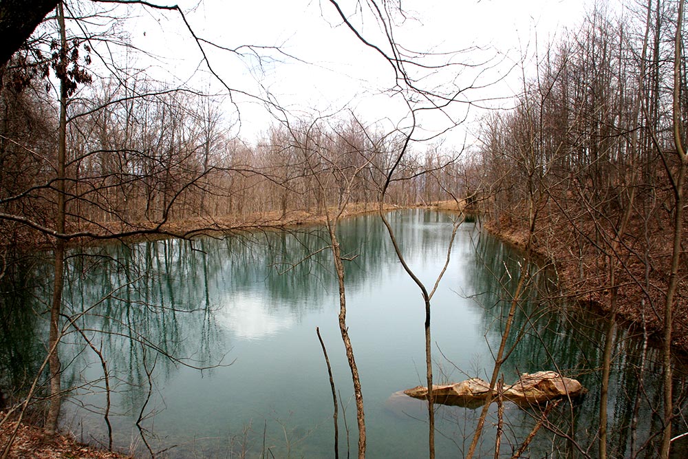
Mile 7.4 (5.6) Leaving Grassy Gap, begin a series of switchbacks reaching a pond (2,929 feet). Although this provides a nice lunch spot or break area, do not obtain any water here as it is likely polluted from coal mining in the area. After passing the pond, the trail continues a descent into the Straight Fork watershed.
Mile 8.0 (5.0) The shaded, cool cove against Arch Mountain (2,730 feet) is welcome after the exposed, dry ridgeline of Smoky Mountain. There are numerous flowing creeks suitable for drinking after treating and spots for LNT camping.
Mile 8.6 (4.4) A beautiful cascade in a side creek offers a nice photo opportunity as well a good water source (2,098 feet).
Mile 9.0 (4.0) Cross Straight Fork (1,694 feet), paying extra attention to the unusual amount of slime on the rocks so you don’t slip. Turn left and ascend to a logging road.
Mile 9.1 (3.9) Cross the logging road and veer left along the base of Smoky Mountain, staying on the east side of Straight Fork.
Mile 9.3 (3.7) The sound of rushing water invites you to turn right 25 yards from the trail for another cascade in a side creek. This is a nice LNT campsite or a great area for a break.
Mile 9.8 (3.2) The trail continues to descend until reaching a nice flat wooded area for another LNT campsite (1,560 feet) beside Straight Fork.
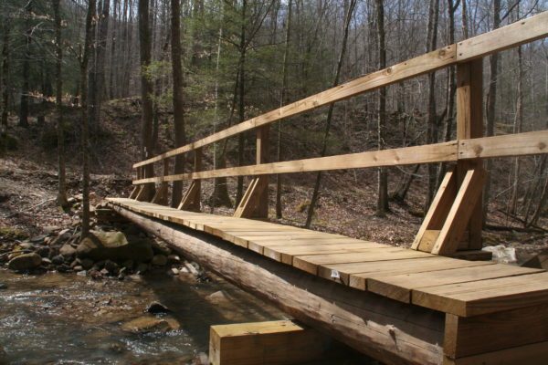
Mile 10.0 (3.0) Cross a footbridge over Straight Fork, and then cross a gravel road and turn uphill, staying on the west side of Straight Fork along the base of Arch Mountain’s eastern slope.
Mile 10.1 (2.9) The trail reaches a small bridge over an orange-colored creek. The creekbed and rocks have been stained from sulfides leached from an abandoned coal mine; do not take any water here.
Mile 10.4 (2.6) The trail merges onto a railroad bed that was used to move coal from these mountains.
Mile 10.5 (2.5) The trail enters a strip mine reclamation area at the base of Arch Mountain (1,418 feet).
Mile 11.0 (2.0) There is a small creek crossing and another visible cascade worth stopping for another photograph.
Mile 11.5 (1.5) The trail moves away from the creek and ascends into a wooded area.
Mile 11.6 (1.4) Continue on the trail, taking a sharp left up a ravine before reaching a flat area LNT campsite.
Mile 11.9 (1.1) Traverse downhill, leaving the north end of the strip mine reclamation area. Cross a road and continue downhill before reaching an old railroad bed beside Smoky Creek (1,319 feet).
Mile 12.3 (0.7) The trail provides a peaceful and easy walk next to the creek.
Mile 12.9 (0.1) There is no bridge for crossing Smoky Creek, so a ford is necessary. Look for the shallowest route as the water whitecaps over the rocks.
Mile 13.0 (0.0) The trail emerges on Smoky Creek Road. This is the northern terminus of the Arch Mountain Section (1,308 feet). The southern end of the Lawson Mountain Section is directly across the road.
—Bobby Trotter, Smoky Mountains Hiking Club