Soddy Creek Gorge (South)
Little Soddy TH to Mowbry Pike
Overview
This stretch of the Soddy Creek section is the southern portion of the Three Gorges Segment, a 30+ mile contiguous piece of the Cumberland Trail. It will connect to the south with the North Chickamauga Creek Segment (route to be determined) and proceeds northward from Little Soddy Creek for another 12 miles to its junction with the Possum Creek Section of the Three Gorges Segment.
This stretch includes the Little Soddy Historic Mining Area (BROCHURE). The access trail from the Sluder Lane Trail Head (blazed blue) was built during the first “Big Dig,” a volunteer trail-building event in 2003. The access trail was completed as a loop trail during Winter BreakAway 2012 by students from the University of Kansas.
The main trail was constructed over the following two years. Highlights include spectacular views of the valley from the escarpment, boulders and rock formations, and at the northern end, a historic walk through the remnants of one the oldest tunnel coal-mining operations in Tennessee.
Trail Section Details
Features:
- Swimming
- Wildflowers
- Fall color
Counties:
- Hamilton
Distance:
4.9 miles
Difficulty:
Moderate
Elevation Change:
450 feet
Northern Terminus:
Hotwater Road/Little Soddy (N35 16.889 W85 11.636)
Southern Terminus:
Mowbray Pike (N35 15.292 W85 12.153)
Timezone:
EDT
Cautions:
High bluffs
Camping:
No camping allowed on this stretch. As the area was heavily mined, the creeks and streams contain mine run-off; best to carry your water with you.
Topographic Maps:
Soddy Quadrangle
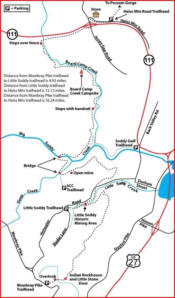
Trailheads
The southern end of this section is accessible from US 27.
From Chattanooga, take US 27 north to Sequoyah Road in Daisy. Turn right on Sequoyah Road and travel one-half mile to the intersection with Dayton Pike. Turn left on Dayton Pike and proceed 1.1 miles to the intersection with Mountain Road. Turn right on Mountain Road and proceed 1.8 miles to the trailhead on the right. (Note: Mountain Road becomes Mowbray Pike.)
The northern end can be accessed from the Little Soddy Trailhead.
From Chattanooga take US 27 north to the TN 319 Hixson Pike exit. Exit and turn left back over the highway to the T intersection at Dayton Pike. Turn right and continue 0.7 mile to Durham St. Turn left, with Soddy Lake on your right. Go 0.6 mile to a T intersection at Back Valley Rd. Turn right and travel one block to a four-way stop at Hotwater Rd. Turn left. Follow Hotwater Rd. two miles through Little Soddy Creek Gorge until you crest the hill and reach Sluder Lane on your left.
Park on the gravel at the corner of Sluder and Hotwater Rd. The trailhead is about 200 feet back down Hotwater Rd. on your right.
Map
Description
Description: South to North (North to South)
Mile 0.0 (4.9) At the Mowbray Pike Trailhead, the CT begins with 4 wooden steps at the back of the parking lot. Pass through a pine grove.
Mile 0.1 (4.8) Cross the first of many coal seams.
Mile 0.2 (4.7) Cross a small seasonal stream.
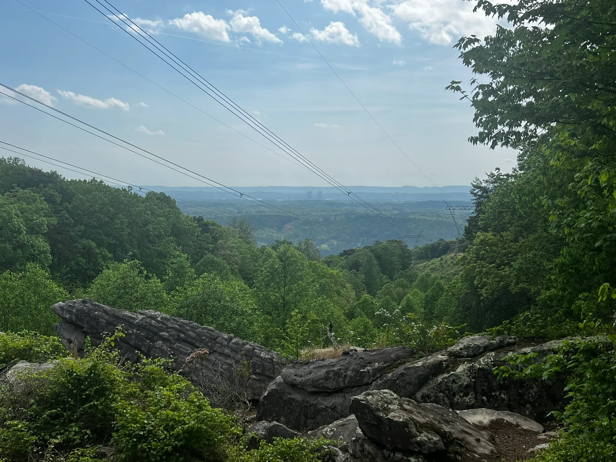
Mile 0.3 (4.6) Cross the power line right of way and overlook the town of Daisy; the twin cooling towers of TVA’s Sequoyah power plant are seen in the distance.
Mile 0.4 (4.5) Cross Mikel Branch; just downstream from the footbridge the creek drops over waterfall. The trail meanders through a boulder field.
Mile 0.5 (4.4) Pass through “Little Stone Door,” a gap through some very large boulders and descend to the base of the bluff line.
Mile 0.6 (4.3) Note the rock house on the left. An archaeologist has verified that the opening once served as shelter for Native Americans. Rhododendron, honeysuckle, and spice shrubs abound here in the spring.
Mile 0.9 (4.0) Another rock house on the left may also offer hikers shelter in the event of a sudden storm.
Mile 1.3 (3.6) Cross another seasonal stream; pinxter azaleas, blooming a pale coral, are in full bloom here in early spring.
Mile 1.6 (3.3) Cross another coal seam.
Mile 1.7 (3.2) Enter a pine grove; to the right is a small overlook, and in late spring the abundant blueberry bushes offer the hiker a tasty snack to those fortunate enough to beat the birds to them.
Mile 2.2 (2.7) Carol’s Bench—a long natural rock bench named for Wagonmaster Carol Haley, whose spring breakaway student crew built this stretch of trail and availed themselves of this bench to take their lunch break. Approximately midway between the Mowbray Pike and Sluder Lane trailheads, the bench provides an excellent spot to sit back and take a rest. You may hear the sound of a train whistle drifting up from the valley below.
Mile 2.5 (2.4) The trail picks its way through a rock field, one of which serves as another natural bench facing the valley that offers winter views.
Mile 2.6 (2.3) Pause here and enjoy the view from the escarpment. White dogwood blooms are seen dotting the woods in late April, and the blackberry bushes growing here bear their fruit in early to mid July.
Mile 2.9 (2.0) Begin walking atop a narrow mine tailing with the valley floor on your right and a strip mine trench to your left. Notice the “cuts” in the ridge; these were made to drain the trench. This spot is an excellent example of nature’s ability to heal itself.
Mile 3.3 (1.6) Cross the strip mine trench at its head and begin the switchback ascent to Clemmons Point.
Mile 3.4 (1.5) Clemmons Point, known to locals as “Clements Point,” is named for the Clements family, who either owned the land or operated a blacksmith shop in the area.
Mile 3.5 (1.4) The roadbed the trail is now on is the site of the coal vein. In April the old roadbed is a fern garden.
Mile 4.0 (0.9) One of several large dirt mounds, tailings left over from mining days.
Mile 4.3 (0.6) Here the roadbed is covered with ground pine. After a spring rain, the natural low of the trail can be a bit wet.
Mile 4.4 (0.5) Cross a footbridge over a drainage gulch, made to drain the mine over the side to your right. Dwarf crested iris are abundant here in early spring.
Mile 4.5 (0.4) Intersection with access trail to Sluder Lane Trailhead (blazed blue). At this intersection, the hiker enters the Little Soddy Historic Mining Area—a Walk in History (see also Mining History Synopsis). The area can be very wet at times, but stepping stones have been strategically placed. Feeding into this “wetland” is the oldest mine in Tennessee, opened in 1866 by the Soddy Coal Company (site # 3). Turn left to ascend toward the Sluder Lane Trailhead. (If continuing on the CT, you would bear right to across a bridge over Little Soddy Creek and reaching Hotwater Road in 0.7 mile.)
Mile 4.7 (0.2) Ore car path (site #2). Soon after, reach a junction with historic area loop trail (blazed yellow) to the right that circles back to connect with the CT to the north.
Cross a wooden bridge over Little Soddy Creek and begin a rocky and steep (but mercifully short) climb out of the Little Soddy Gorge. In early to mid-spring, fiddlehead ferns grow along here; the stems are edible and reportedly taste “just like asparagus.” Do not eat unless you’re sure of what you’re eating.
Mile 4.8 (0.1) Fibrothers Mine (originally “Five Brothers”), named for the five Millsaps brothers (site #1).
Mile 4.9 (0.0) Kiosk/footbridge. Go up the slope, turn left onto Hotwater Rd. and walk 200 feet to the parking lot at the Little Soddy Trailhead.
— Caroline Woerner, CTC volunteer, with Jim Schroeder, long-time CTC volunteer, past board member, wagon master, and CTC Hall of Fame member
More Information
A Walk in History
Hikers who trek the Little Soddy Creek section of the Cumberland Trail truly walk into history. As one descends the old mining road from Clemmons Point into the south side of the valley, the oldest mine in the state, the original Soddy Mine that opened in 1866, is just “over yonder.” Often water can be seen discharging from the now collapsed and hidden mine entrance.
Upstream from this old mine, near the end of the access trail, is the old Fibrother Mine under the trailhead bluff. This mine was operated by the five Millsap brothers, who were local residents. It is here that Mr. Raymond Redden, a resident in his eighties resided at the intersection of Hotwater Road and Old Hotwater Road, cut and supplied ties for the ore cart tracks as a young man.
On the main trail after crossing Little Soddy Creek, you are in the former center of activity supporting the old No. 7 mine. Just upstream was Mr. Jeffery’s mule barn where up to 48 mine mules were housed. He lived at the head of the gulf (or “gulch” in the local idiom) and his job was caring for the mining mules, which also included repairing the leather harnesses. The only phone was located at the Commissary Shed operated by Paul Thrasher.
Just down stream is the site of a variety of old mine support operations: the boiler house containing two steam boilers, the blacksmith shop, the machinery building containing the steam engine to drive the machinery to control the 7000-foot-long incline cable car system down to the bottom of the gulf, and whatever else was needed to run the mine.
One can almost hear the clanking of machinery, the hissing of the steam engines, the clickety clack of ore cars, the braying of the mules, and the clinking of miners’ lunch boxes as Old No. 7 beckons all to the task at hand—extracting the precious black ore. And nearby sits Mr. (Tom) Levi who controls each of the thirty-unit parades of loaded ore cars that make the descent to the coal washing station at the bottom in but nine minutes.
Following the path of the old incline tracks takes the hiker high above the stream as it plunges rapidly in a series of cascades, soon almost 100 feet below. Near the bottom of the decline can be found one of the old boilers from the upstream power house, lodged in the stream bed near where the incline made one of its seven stream crossings on its way down the valley. One may occasionally spot a relic of the past—a section of track, an ore car wheel, a piece of cable—as the hiker passes along this historic route.
Skirting up and around the steep north bank brings one again near the stream and across from an old foundation on the south bank; this was a structure housing the potential bane of the mining industry—the blasting dynamite, fuse cord, primers.
Climbing away from this one-time beehive of activity where it is reported that 800+ people were gainfully employed, one can sometimes hear the whistle of a modern train. However it is easy to imagine the clanking of heavily laden cars recently filled by the washer at the base of the mountain, all pulled by the chugging and puffing steam engines of the times.
Leaving the valley, the vision of what was once there is dimmed by time, but the history of activity once performed here is etched forever in the present-day character of the community.
— Jim Schroeder