Brady Mountain
Hwy 68/Brady Mountain TH to Head of Sequachie
Overview
The Brady Mountain Section includes a beautiful ridge-line hike with a panoramic lookout over Grassy Cove at Brady Bluff Overlook. Much of the trail follows old overgrown double-track roadbeds. It also crosses several such roadbeds that are not to be followed. Pay special attention to the white blazes after crossing the dirt logging road at 0.6 miles from the start at the Jewett Road Trailhead. At 1.4 miles the trail follows Brady Ridge on a roadbed and the trail becomes much more obvious to follow.
Trail Section Details
Features:
- Overlooks
- Wildflowers
- Fall color
- Bluffs
Distance:
7.8 miles
Difficulty:
Strenuous
Elevation Change:
800
Northern Terminus:
Brady Mountain at TN Route 68. (El. 1,816′ N35 52.188 W84 55.753)
Southern Terminus:
Jewett Road (El. 2,118′ N35 47.542 W84 58.583)
Timezone:
CDT
Cautions:
Some rocky steep sections; cumulative elevation change of 2000 feet.
Camping:
None
Water Sources:
Water Source: N35° 49′ 5.664″ W84° 58′ 36.948″
Trailheads
Brady Mountain Trailhead; take TN 68 for 4.6 miles from the Highway 68/127 junction just east of Crossville, Tennessee. The trailhead is a large paved pull-off on the right at the top of the rise above Grassy Cove. Brady Mountain Trailhead serves as the southern terminus for the Black Mountain Section and the northern terminus for the Brady Mountain Section.
Jewett Road Trailhead; continue on TN 68 through Grassy Cove for 8.4 miles to a right turn on Jewett Road. Follow Jewett Road for 6.6 miles to the trailhead. Trailhead is easy to overlook, so drive slow and watch carefully for the wooden posts where the trailhead sign used to be on the right several yards off the road. There is no constructed trailhead parking area, only a wide spot in the road. There is parking directly across the road from the trailhead that is large enough for 1 average size car or maybe two small cars. There is another wide spot in the road about 200 feet past the trailhead that is large enough for 2 or 3 cars.
The Jewett Road Trailhead can also be reached from US 127 north of Pikeville. However, this access is in very rough shape and should only be attempted by high clearance or off-road vehicles. Turn right on Rhea Road (unmarked, 0.1 miles north of Vandever Rd. on left). Go 1.5 miles then turn left on Old TN 28. Go 1.3 miles then turn right on Hinch Road (aka Happytop Road which turns into Jewett Road). Go 4.1 miles on Hinch/Happytop/Jewett road and reach the trailhead described above.
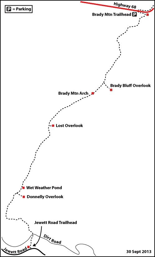
Map
Description
Mile 0.0 (7.8) Jewett Road Trailhead (N35 47.541 W84 58.591, elevation 2118 feet). Leave the trailhead and go up at a steady grade northeast for 0.1 then veer right and level off briefly. After two quick switchbacks resume an uphill northeast climb. A gully with wet weather drainage is to the right.
Mile 0.5 (7.3) Cross a dirt logging road at Key Reed Gap. This is a saddle with Dorton Knob (2979 feet) to the left. The trail continues straight across the logging road. A white blaze is visible across the road. Take the faint single-track trail to the left of the blaze. Do not follow the overgrown roadbed to the right of the blaze. The trail veers west and continues to climb.
At 0.6 miles the trail intersects a dirt roadbed. Turn right here. Note that this junction is easy to miss coming down when doing this section north to south.
Mile 0.8 (7.0) Reach a junction with a double white blaze. Keep left and uphill. Continue another 0.1 miles and reach another trail junction with double white blazes. Stay left and level for about 0.15 miles and reach a third double blaze. This time go right and start ascending again. Go another 0.15 miles, cross a roadbed and proceed straight and uphill.
Mile 1.3 (6.5) Crest a local unnamed peak as the trail curves toward the north. Descend for 0.3 mile and start climbing again north and slightly east. This begins the main northeast traverse of Brady Ridge.
Mile 1.8 (6.0) Pass a large boulder on the right at 1.8 miles. This is called Donnelly’s Window (N35 48.574 W84 58.887, elevation 2796 feet). Continue climbing gradually then level off at 2.3 miles. Continue relatively level for 0.8 miles and reach a double-blazed junction. Stay right (left) here and start the ascent to the summit of Brady Mountain.
Mile 1.9 (5.9) Spur trail on right (left) (N35 48.625 W84 58.861) to Donnelly’s Overlook (N35 48.601 W84 58.805).
Mile 3.2 (4.6) Reach the peak of Brady Mountain (N35 49.604 W84 58.256, elevation 2923 feet). Begin descending and intersect a faint unmarked spur trail to the right after 0.6 miles.
Mile 3.8 (4.0) Spur trail on right (left) (N35 50.019 W84 58.041) to Lost Overlook (N35 50.003 W84 58.007). The short spur leads to an obstructed view of Grassy Cove. Continue descending on the main trail for another 0.2 miles then crest a local peak at 4.8 miles. Continue straight and down for 0.3 miles.
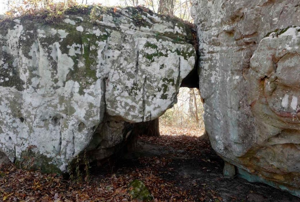
Mile 5.1 (2.7) Come to Brady Mountain Arch (N35 50.569 W84 57.069) at 5.1 miles. Elevation 2671 feet. This is short, square, window shaped arch with large surrounding boulders. Leave the arch and the trail begins a slight ascent.
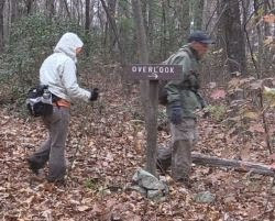
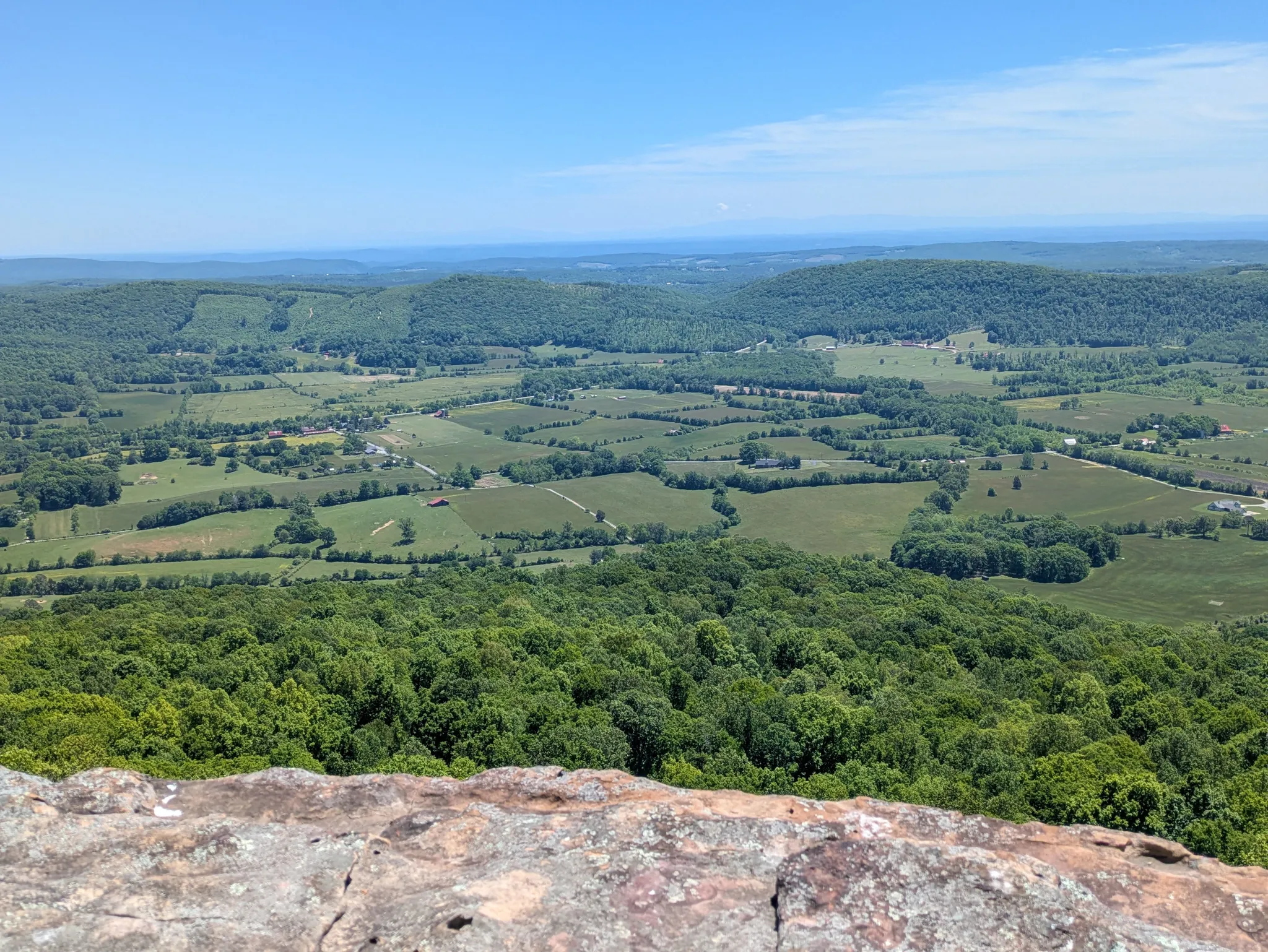
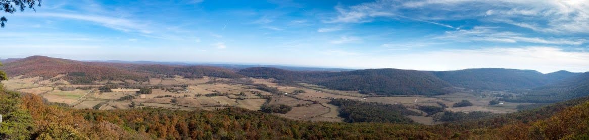
Mile 5.5 (2.3) Arrive at a sign labelled “Overlook” with a right-pointing arrow. This may be the most underrated trail sign in the history of signage. Take the spur trail right (left) and down for 0.1 miles. Brady Bluff Overlook (N35 50.716 W84 56.668′, elevation 2624 feet) provides a 180 degree panoramic view of Grassy Cove about 1000 feet below. The overlook is atop a rock pillar approximately 250 tall and provides a semicircular “balcony” from which to view the cove and surrounding peaks. This surely ranks as one of the best, if not the best, overlooks on the Cumberland Trail. The panorama below doesn’t scratch the surface of the beauty of the view. Return 0.1 miles back up to the Overlook sign. Leave the Overlook sign and continue on the single path trail.
Mile 6.7 (1.1) Low Gap (N35 51.629 W84 56.419, elevation 2135 feet). Go 0.3 miles and reach a large boulder then begin a steep descent. Go 0.7 miles and bear right at a junction and arrive shortly at Low Gap. Bear right on an overgrown roadbed.
Mile 7.8 (0.0) Brady Mountain Trailhead (N35 52.188 W84 55.753). Leave Low Gap and ascend slightly for 0.2 miles then start descending. After 0.4 miles bear right at an obvious junction. Continue descending and reach the Brady Mountain Trailhead Kiosk on TN 68 at 7.8 miles.
– Description courtesy of CTC Volunteer Gary Stephens
More Information
Trail Construction
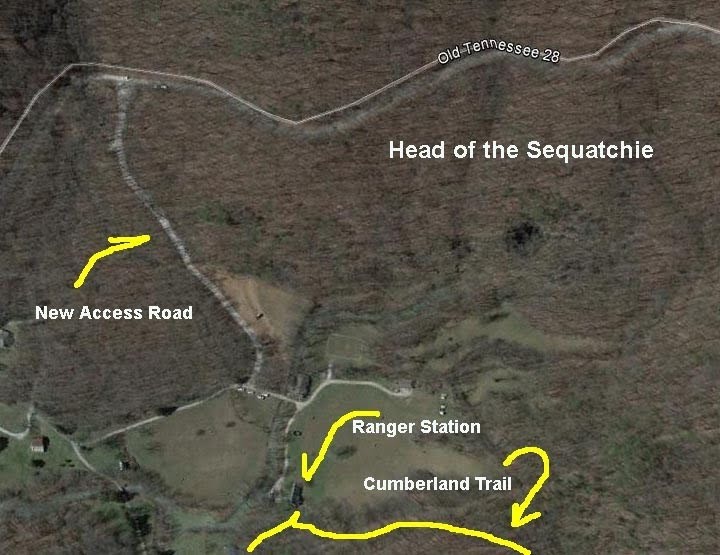
The trail from Jewett Road down to the ranger station needs one more mile to be built. Completion date is unknown. When it is officially open, Head of the Sequatchie will become the Southern terminus of the Brady Mountain Section within the larger Grassy Cove Segment. This will allow a shuttle hike from HOS to Black Mountain of about 15 miles.
June 2017 Update
A new trailhead and ranger station are open at Head of the Sequatchie as of June 2017. The trail connection from HOS north to Jewett Road and the Brady Mountain Section is underdevelopment.
Parking in HOS : A new access road was built in 2017. The area is gated and open only on specific days. Latest information is the Head of Sequatchie area will be open 8am – 4:30pm Central Time on scheduled days.
Vehicles left in gated areas after sunset are subject to being towed or locked in. Overnight parking is allowed by permit at designated trailheads only.
For opening information contact the Cumberland Trail State Scenic Trail office at:423-566-2229 .
Check this link for the Park calendar
Connection to Black Mountain Section: at Brady Mountain TN RT 68 Trailhead
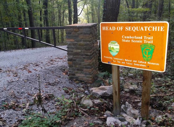
Head of the Sequatchie Information
Head of the Sequatchie Ranger Station
Parking in HOS :
The Head of Sequatchie is open daily from 9am to 5pm Central Time.
Directions/Details: http://www.friendsofthecumberlandtrail.org/directions-to-head-of-sequatchie-management-area/ or call 423-566-2229 (M-F 8am to 4:30pm ET).
Vehicles left in gated areas after sunset are subject to being towed or locked in. Overnight parking is allowed by permit at designated trailheads only.
For more information, contact the Cumberland Trail State Scenic Trail office at:423-566-2229 .
Google Maps link HERE
Directions from Nashville to Sequatchie Valley
- From I-40 East, turn of and take the Peavine Road exit #322 from the interstate. As you turn off the interstate go up the ramp and at the top turn right .
- Continue straight to a 4 way stop, after stopping, go straight. You are now on the Miller Bypass around Crossville.
- Follow the bypass to the next traffic light. Turn left. You are now on Hwy 127 going south.
- Follow 127 south. In 2.4 miles stay right at the split for TN 68. Stay on 127. From the highway 68 split to the main entrance for Cumberland Mountain SP is .6 miles.
- Continue south on highway 127 for roughly 2 miles. At a small gas station take the fork to the LEFT. Street sign says “Old TN 28.”
- Follow Old TN 28 for approximately 5 miles. The road forks at a recycling station on the left. Take the left fork – more or less straight. The road to the right is Rhea Road. The mountains visible to the left are the Crab Orchard Mountains.
- Follow Old highway 28 about 2.5 miles.
- Turn left at the brown Head of the Sequatchie sign. This access road was built in 2017. At the bottom of the road, turn left and follow signs for parking.
Directions from Knoxville to the Sequatchie Valley
- From I-40 East take the Peavine Road exit #322 from the interstate. At the top of the ramp, turn left.
- Continue thru the next traffic light. You will come to a 4 way stop, after stopping go straight. You are now on the bypass around Crossville.
- Follow the by pass to the next traffic light. Turn left. You are now on Hwy 127 going south.
- Follow 127 south. In 2.4 miles stay right at the split for TN 68. Stay on 127. From the highway 68 split to the main entrance to Cumberland Mountain SP is .6 miles.
- Continue south on highway 127 for roughly 2 miles. At a small gas station take the fork to the LEFT. Street sign says “Old TN 28.”
- Follow Old TN 28 for approximately 5 miles. The road forks at a recycling station on the left. Take the left fork – more or less straight. The road to the right is Rhea Road. The mountains visible to the left are the Crab Orchard Mountains.
- Follow Old highway 28 about 2.5 miles.
- Turn left at the brown Head of the Sequatchie sign. This access road was built in 2017. At the bottom of the road, turn left and follow signs for parking.
Trailheads
Brady Mountain Trailhead
Brady Mountain at TN Route 68. (El. 1,816′ N35 52.188 W84 55.753)
To reach the Brady Mountain trailhead, take Highway 68 for 4.6 miles from the Highway 68/127 junction just east out of Crossville, Tennessee. The trail head is a large paved pull off on the right at the top of the rise above Grassy Cove. Brady Mountain Trailhead serves as the Southern Terminus for the Black Mountain Section and the Northern Terminus for the Brady Mountain Section.
Enter the woods on the south side of RT. 68. There is a CT kiosk with maps. The trail begins an assent up an old logging road. A full trail description for Brady Mountain Section is HERE.
Jewett Road Trailhead
Jewett Road (El. 2,118′ N35 47.542 W84 58.583)
Follow directions above to Brady Mt trail head. Then continue on TN 68 through Grassy Cove for 8.4 miles to a right turn on Jewett Road. Follow Jewett Road for 6.6 miles to the trailhead. Trailhead is easy to overlook, so drive slow and watch carefully for the wooden posts where the trailhead sign used to be on the right several yards off the road. There is no constructed trailhead parking area, only a wide spot in the road. There is parking directly across the road from the trailhead that is large enough for 1 average size car or maybe two small cars. There is another wide spot in the road about 200 feet past the trailhead that is large enough for 2 or 3 cars.
The Jewett Road Trailhead can also be reached from US 127 north of Pikeville. Turn right on Rhea Road (unmarked, 0.1 miles north of Vandever Rd. on left). Go 1.5 miles then turn left on Old TN 28. Go 1.3 miles then turn right on Hinch Road (aka Happytop Road which turns into Jewett Road). Go 4.1 miles on Hinch/Happytop/Jewett road and reach the trailhead described above.